


La Pène

ARVIEU
User
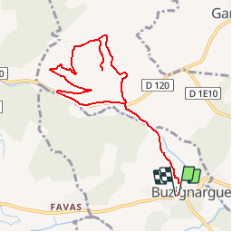

Length
9.8 km

Max alt
251 m

Uphill gradient
248 m
Km-Effort
13.1 km

Min alt
52 m

Downhill gradient
247 m
Boucle
Yes
Creation date :
2015-11-24 00:00:00.0
Updated on :
2015-11-24 00:00:00.0
1h00
Difficulty : Difficult

FREE GPS app for hiking
 SityTrail
IGN / Geographical institutes
SityTrail Plus
The world is yours!
About
Trail Running of 9.8 km to be discovered at Occitania, Hérault, Buzignargues. This trail is proposed by ARVIEU.
Description
Montée de la Pène
Positioning
Country:
France
Region :
Occitania
Department/Province :
Hérault
Municipality :
Buzignargues
Location:
Unknown
Start:(Dec)
Start:(UTM)
580660 ; 4846831 (31T) N.
Comments