


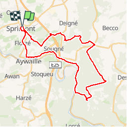
sprimont chefna chemins empierrés

pqa621@gmail.com
User

Length
34 km

Max alt
439 m

Uphill gradient
758 m
Km-Effort
45 km

Min alt
120 m

Downhill gradient
758 m
Boucle
Yes
Creation date :
2015-11-29 00:00:00.0
Updated on :
2015-11-29 00:00:00.0
2h33
Difficulty : Medium

FREE GPS app for hiking
 SityTrail
IGN / Geographical institutes
SityTrail Plus
The world is yours!
About
Trail Cycle of 34 km to be discovered at Wallonia, Liège, Sprimont. This trail is proposed by pqa621@gmail.com.
Description
Par temps humide bon plan pour dénivelles dans grande nature
Positioning
Country:
Belgium
Region :
Wallonia
Department/Province :
Liège
Municipality :
Sprimont
Location:
Sprimont
Start:(Dec)
Start:(UTM)
689023 ; 5598013 (31U) N.
Comments