


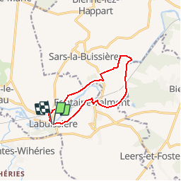
De Labuissiere vers Fontaine-Valmont par la Vallee de la Sambre

Desrumaux
User GUIDE

Length
9.2 km

Max alt
152 m

Uphill gradient
119 m
Km-Effort
10.8 km

Min alt
114 m

Downhill gradient
121 m
Boucle
Yes
Creation date :
2014-12-10 00:00:00.0
Updated on :
2014-12-10 00:00:00.0
2h15
Difficulty : Easy

FREE GPS app for hiking
 SityTrail
IGN / Geographical institutes
SityTrail Plus
The world is yours!
About
Trail Walking of 9.2 km to be discovered at Wallonia, Hainaut, Merbes-le-Château. This trail is proposed by Desrumaux.
Description
Details sur TraceGPS.com
http://www.tracegps.com/fr/parcours/circuit5863.htm
Positioning
Country:
Belgium
Region :
Wallonia
Department/Province :
Hainaut
Municipality :
Merbes-le-Château
Location:
Labuissière
Start:(Dec)
Start:(UTM)
585083 ; 5574210 (31U) N.
Comments
super