


13 Col Ste Anne- Pilon du Roi

ARPF
User
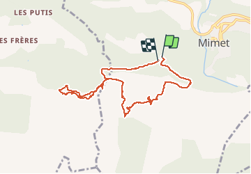

Length
10.3 km

Max alt
718 m

Uphill gradient
509 m
Km-Effort
17.1 km

Min alt
416 m

Downhill gradient
504 m
Boucle
Yes
Creation date :
2017-03-31 00:00:00.0
Updated on :
2017-03-31 00:00:00.0
3h39
Difficulty : Difficult

FREE GPS app for hiking
 SityTrail
IGN / Geographical institutes
SityTrail Plus
The world is yours!
About
Trail Walking of 10.3 km to be discovered at Provence-Alpes-Côte d'Azur, Bouches-du-Rhône, Mimet. This trail is proposed by ARPF.
Description
P2 T3
Rochers plats glissants si pluie.
Contournement Station émettrice - Pylône "escalade" niveau T3 (vertigineux).
Positioning
Country:
France
Region :
Provence-Alpes-Côte d'Azur
Department/Province :
Bouches-du-Rhône
Municipality :
Mimet
Location:
Unknown
Start:(Dec)
Start:(UTM)
701730 ; 4809509 (31T) N.
Comments