


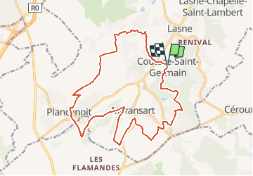
De Couture-Saint-Germain vers Plancenoit par la vallee de la Lasne

Desrumaux
User GUIDE

Length
17.7 km

Max alt
139 m

Uphill gradient
328 m
Km-Effort
22 km

Min alt
72 m

Downhill gradient
334 m
Boucle
Yes
Creation date :
2014-12-10 00:00:00.0
Updated on :
2014-12-10 00:00:00.0
4h15
Difficulty : Medium

FREE GPS app for hiking
 SityTrail
IGN / Geographical institutes
SityTrail Plus
The world is yours!
About
Trail Walking of 17.7 km to be discovered at Wallonia, Walloon Brabant, Lasne. This trail is proposed by Desrumaux.
Description
Details sur TraceGPS.com
http://www.tracegps.com/fr/parcours/circuit5512.htm
Positioning
Country:
Belgium
Region :
Wallonia
Department/Province :
Walloon Brabant
Municipality :
Lasne
Location:
Couture-Saint-Germain
Start:(Dec)
Start:(UTM)
604467 ; 5614610 (31U) N.
Comments
toujours de belles balades