


2016-04-28 Rando CVA 2016 Luberon Cereste Boucle Reillanne

holtzv
User GUIDE
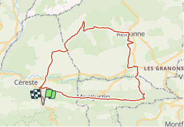

Length
22 km

Max alt
611 m

Uphill gradient
567 m
Km-Effort
30 km

Min alt
366 m

Downhill gradient
566 m
Boucle
Yes
Creation date :
2016-04-15 00:00:00.0
Updated on :
2016-04-15 00:00:00.0
3h35
Difficulty : Unknown

FREE GPS app for hiking
 SityTrail
IGN / Geographical institutes
SityTrail Plus
The world is yours!
About
Trail Equestrian of 22 km to be discovered at Provence-Alpes-Côte d'Azur, Alpes-de-Haute-Provence, Céreste. This trail is proposed by holtzv.

Positioning
Country:
France
Region :
Provence-Alpes-Côte d'Azur
Department/Province :
Alpes-de-Haute-Provence
Municipality :
Céreste
Location:
Unknown
Start:(Dec)
Start:(UTM)
709121 ; 4857921 (31T) N.
Comments