


pr issendolus

lafage
User
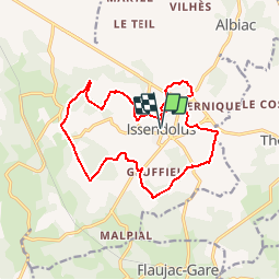

Length
15.9 km

Max alt
352 m

Uphill gradient
230 m
Km-Effort
19 km

Min alt
302 m

Downhill gradient
230 m
Boucle
Yes
Creation date :
2015-12-08 00:00:00.0
Updated on :
2015-12-08 00:00:00.0
4h06
Difficulty : Easy

FREE GPS app for hiking
 SityTrail
IGN / Geographical institutes
SityTrail Plus
The world is yours!
About
Trail Walking of 15.9 km to be discovered at Occitania, Lot, Issendolus. This trail is proposed by lafage.
Description
balisage jaune
Positioning
Country:
France
Region :
Occitania
Department/Province :
Lot
Municipality :
Issendolus
Location:
Unknown
Start:(Dec)
Start:(UTM)
403989 ; 4955062 (31T) N.
Comments
Très bon balisage, paysage typique du causse vallonné, mais sans trop de dénivelé.