Balade en forêt Ardennaise - De Landrichamps à Charnois

Desrumaux
User GUIDE
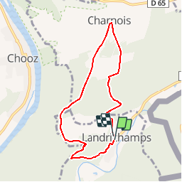

Length
6.5 km

Max alt
322 m

Uphill gradient
313 m
Km-Effort
10.6 km

Min alt
142 m

Downhill gradient
306 m
Boucle
Yes
Creation date :
2014-12-10 00:00:00.0
Updated on :
2014-12-10 00:00:00.0
1h40
Difficulty : Easy

FREE GPS app for hiking
 SityTrail
IGN / Geographical institutes
SityTrail Plus
The world is yours!
About
Trail Walking of 6.5 km to be discovered at Grand Est, Ardennes, Landrichamps. This trail is proposed by Desrumaux.
Description
Détails de la rando sur TraceGPS.com
http://www.tracegps.com/fr/parcours/circuit2597.htm
Positioning
Country:
France
Region :
Grand Est
Department/Province :
Ardennes
Municipality :
Landrichamps
Location:
Unknown
Start:(Dec)
Start:(UTM)
630865 ; 5550171 (31U) N.
Comments