


L'Erié-Sorniot-Demèchre-Portail de Fully-L'Erié

jipi2
User
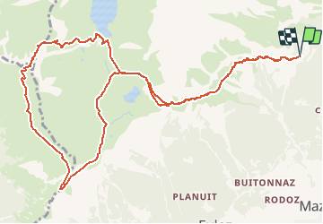

Length
14.2 km

Max alt
2450 m

Uphill gradient
815 m
Km-Effort
25 km

Min alt
1880 m

Downhill gradient
819 m
Boucle
Yes
Creation date :
2015-12-28 00:00:00.0
Updated on :
2015-12-28 00:00:00.0
6h45
Difficulty : Easy

FREE GPS app for hiking
 SityTrail
IGN / Geographical institutes
SityTrail Plus
The world is yours!
About
Trail Walking of 14.2 km to be discovered at Valais/Wallis, Martigny, Fully. This trail is proposed by jipi2.


Positioning
Country:
Switzerland
Region :
Valais/Wallis
Department/Province :
Martigny
Municipality :
Fully
Location:
Unknown
Start:(Dec)
Start:(UTM)
355765 ; 5114926 (32T) N.
Comments