


Cabane des Vignettes-Refuge Nacamuli

jipi2
User
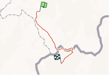

Length
8.1 km

Max alt
3386 m

Uphill gradient
427 m
Km-Effort
14.9 km

Min alt
2781 m

Downhill gradient
741 m
Boucle
No
Creation date :
2015-12-30 00:00:00.0
Updated on :
2015-12-30 00:00:00.0
3h20
Difficulty : Difficult

FREE GPS app for hiking
 SityTrail
IGN / Geographical institutes
SityTrail Plus
The world is yours!
About
Trail Walking of 8.1 km to be discovered at Valais/Wallis, Hérens, Evolène. This trail is proposed by jipi2.


Positioning
Country:
Switzerland
Region :
Valais/Wallis
Department/Province :
Hérens
Municipality :
Evolène
Location:
Unknown
Start:(Dec)
Start:(UTM)
381968 ; 5094074 (32T) N.
Comments