


Cabane des Aiguilles Rouges

jipi2
User
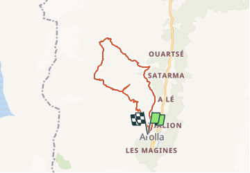

Length
12.8 km

Max alt
2831 m

Uphill gradient
913 m
Km-Effort
25 km

Min alt
2041 m

Downhill gradient
919 m
Boucle
Yes
Creation date :
2015-12-30 00:00:00.0
Updated on :
2015-12-30 00:00:00.0
5h34
Difficulty : Very difficult

FREE GPS app for hiking
 SityTrail
IGN / Geographical institutes
SityTrail Plus
The world is yours!
About
Trail Walking of 12.8 km to be discovered at Valais/Wallis, Hérens, Evolène. This trail is proposed by jipi2.


Positioning
Country:
Switzerland
Region :
Valais/Wallis
Department/Province :
Hérens
Municipality :
Evolène
Location:
Unknown
Start:(Dec)
Start:(UTM)
382312 ; 5098165 (32T) N.
Comments