


Fontanges / vabre

jerome1246
User
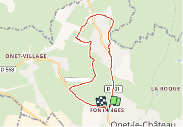

Length
7.6 km

Max alt
603 m

Uphill gradient
118 m
Km-Effort
9.1 km

Min alt
538 m

Downhill gradient
119 m
Boucle
Yes
Creation date :
2015-12-30 00:00:00.0
Updated on :
2015-12-30 00:00:00.0
40m
Difficulty : Unknown

FREE GPS app for hiking
 SityTrail
IGN / Geographical institutes
SityTrail Plus
The world is yours!
About
Trail Running of 7.6 km to be discovered at Occitania, Aveyron, Onet-le-Château. This trail is proposed by jerome1246.
Positioning
Country:
France
Region :
Occitania
Department/Province :
Aveyron
Municipality :
Onet-le-Château
Location:
Unknown
Start:(Dec)
Start:(UTM)
465377 ; 4913925 (31T) N.
Comments