


Col de la Buffaz

Brusa
User
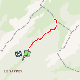

Length
6.2 km

Max alt
1534 m

Uphill gradient
540 m
Km-Effort
13.4 km

Min alt
984 m

Downhill gradient
542 m
Boucle
Yes
Creation date :
2016-01-02 00:00:00.0
Updated on :
2016-01-02 00:00:00.0
2h47
Difficulty : Easy

FREE GPS app for hiking
 SityTrail
IGN / Geographical institutes
SityTrail Plus
The world is yours!
About
Trail Walking of 6.2 km to be discovered at Auvergne-Rhône-Alpes, Upper Savoy, Thônes. This trail is proposed by Brusa.
Positioning
Country:
France
Region :
Auvergne-Rhône-Alpes
Department/Province :
Upper Savoy
Municipality :
Thônes
Location:
Unknown
Start:(Dec)
Start:(UTM)
292417 ; 5088228 (32T) N.
Comments