


Arboras

ARVIEU
User
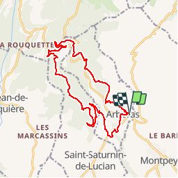

Length
17.9 km

Max alt
601 m

Uphill gradient
513 m
Km-Effort
25 km

Min alt
160 m

Downhill gradient
521 m
Boucle
Yes
Creation date :
2016-01-02 00:00:00.0
Updated on :
2016-01-02 00:00:00.0
5h19
Difficulty : Medium

FREE GPS app for hiking
 SityTrail
IGN / Geographical institutes
SityTrail Plus
The world is yours!
About
Trail Walking of 17.9 km to be discovered at Occitania, Hérault, Arboras. This trail is proposed by ARVIEU.
Description
Arboras montée vers le col du vent et retour par le rocher des Vierges
Positioning
Country:
France
Region :
Occitania
Department/Province :
Hérault
Municipality :
Arboras
Location:
Unknown
Start:(Dec)
Start:(UTM)
539396 ; 4839913 (31T) N.
Comments