


Chassiers

Michel07
User
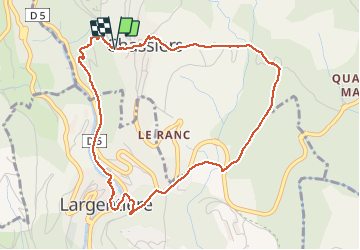

Length
5.2 km

Max alt
361 m

Uphill gradient
202 m
Km-Effort
7.9 km

Min alt
208 m

Downhill gradient
199 m
Boucle
Yes
Creation date :
2016-01-05 00:00:00.0
Updated on :
2016-01-05 00:00:00.0
1h25
Difficulty : Easy

FREE GPS app for hiking
 SityTrail
IGN / Geographical institutes
SityTrail Plus
The world is yours!
About
Trail Walking of 5.2 km to be discovered at Auvergne-Rhône-Alpes, Ardèche, Chassiers. This trail is proposed by Michel07.
Positioning
Country:
France
Region :
Auvergne-Rhône-Alpes
Department/Province :
Ardèche
Municipality :
Chassiers
Location:
Unknown
Start:(Dec)
Start:(UTM)
602788 ; 4933928 (31T) N.
Comments