


Carlus Rayssac Albi

jpipacific
User
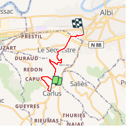

Length
7.3 km

Max alt
264 m

Uphill gradient
113 m
Km-Effort
9 km

Min alt
171 m

Downhill gradient
181 m
Boucle
No
Creation date :
2016-01-06 00:00:00.0
Updated on :
2016-01-06 00:00:00.0
1h38
Difficulty : Easy

FREE GPS app for hiking
 SityTrail
IGN / Geographical institutes
SityTrail Plus
The world is yours!
About
Trail Walking of 7.3 km to be discovered at Occitania, Tarn, Carlus. This trail is proposed by jpipacific.
Description
fin en ville
Positioning
Country:
France
Region :
Occitania
Department/Province :
Tarn
Municipality :
Carlus
Location:
Unknown
Start:(Dec)
Start:(UTM)
428396 ; 4859789 (31T) N.
Comments
