


06/01/2016-BECHEREL nord et sud.Tracé virtuel

babeth35
User
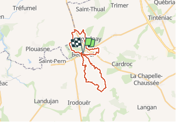

Length
25 km

Max alt
181 m

Uphill gradient
374 m
Km-Effort
30 km

Min alt
81 m

Downhill gradient
367 m
Boucle
Yes
Creation date :
2016-01-06 00:00:00.0
Updated on :
2020-07-20 15:41:36.544
6h30
Difficulty : Unknown

FREE GPS app for hiking
 SityTrail
IGN / Geographical institutes
SityTrail Plus
The world is yours!
About
Trail Walking of 25 km to be discovered at Brittany, Ille-et-Vilaine, Bécherel. This trail is proposed by babeth35.
Positioning
Country:
France
Region :
Brittany
Department/Province :
Ille-et-Vilaine
Municipality :
Bécherel
Location:
Unknown
Start:(Dec)
Start:(UTM)
578411 ; 5349700 (30U) N.
Comments