


Beaulieu-Galargues

ARVIEU
User
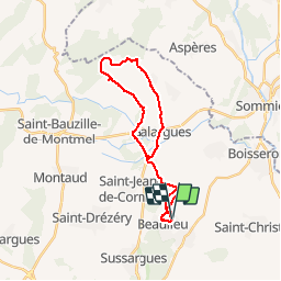

Length
25 km

Max alt
227 m

Uphill gradient
388 m
Km-Effort
30 km

Min alt
40 m

Downhill gradient
391 m
Boucle
Yes
Creation date :
2016-01-06 00:00:00.0
Updated on :
2016-01-06 00:00:00.0
2h00
Difficulty : Medium

FREE GPS app for hiking
 SityTrail
IGN / Geographical institutes
SityTrail Plus
The world is yours!
About
Trail Mountain bike of 25 km to be discovered at Occitania, Hérault, Beaulieu. This trail is proposed by ARVIEU.
Positioning
Country:
France
Region :
Occitania
Department/Province :
Hérault
Municipality :
Beaulieu
Location:
Unknown
Start:(Dec)
Start:(UTM)
582818 ; 4842485 (31T) N.
Comments
Parcours roulant sauf sur un l'ascension du sommet où il faudra Porter le vélo une 12 zaines de minutes