


Puget ville - Le Trou du Boeuf

soca
User
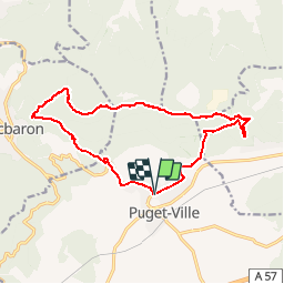

Length
15.7 km

Max alt
588 m

Uphill gradient
530 m
Km-Effort
23 km

Min alt
192 m

Downhill gradient
533 m
Boucle
Yes
Creation date :
2016-01-09 00:00:00.0
Updated on :
2016-01-09 00:00:00.0
4h41
Difficulty : Medium

FREE GPS app for hiking
 SityTrail
IGN / Geographical institutes
SityTrail Plus
The world is yours!
About
Trail Walking of 15.7 km to be discovered at Provence-Alpes-Côte d'Azur, Var, Puget-Ville. This trail is proposed by soca.
Positioning
Country:
France
Region :
Provence-Alpes-Côte d'Azur
Department/Province :
Var
Municipality :
Puget-Ville
Location:
Unknown
Start:(Dec)
Start:(UTM)
267606 ; 4796913 (32T) N.
Comments