


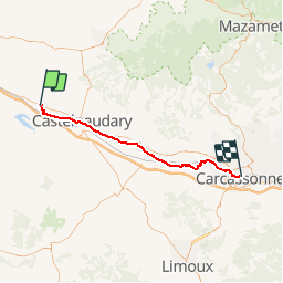
Canal du Midi - Etape 2

frizou83
User

Length
51 km

Max alt
201 m

Uphill gradient
278 m
Km-Effort
55 km

Min alt
103 m

Downhill gradient
357 m
Boucle
No
Creation date :
2016-03-09 00:00:00.0
Updated on :
2016-03-09 00:00:00.0
3h10
Difficulty : Unknown

FREE GPS app for hiking
 SityTrail
IGN / Geographical institutes
SityTrail Plus
The world is yours!
About
Trail Cycle of 51 km to be discovered at Occitania, Aude, Labastide-d'Anjou. This trail is proposed by frizou83.
Description
Labastide-d'Anjou
Carcassonne

Positioning
Country:
France
Region :
Occitania
Department/Province :
Aude
Municipality :
Labastide-d'Anjou
Location:
Unknown
Start:(Dec)
Start:(UTM)
406994 ; 4799918 (31T) N.
Comments