


De Palavas à Maguelone

randotines
User GUIDE

Length
11.8 km

Max alt
13 m

Uphill gradient
49 m
Km-Effort
12.5 km

Min alt
-2 m

Downhill gradient
49 m
Boucle
Yes
Creation date :
2016-01-10 00:00:00.0
Updated on :
2016-01-10 00:00:00.0
2h47
Difficulty : Easy

FREE GPS app for hiking
 SityTrail
IGN / Geographical institutes
SityTrail Plus
The world is yours!
About
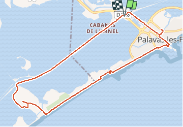
Trail Walking of 11.8 km to be discovered at Occitania, Hérault, Palavas-les-Flots. This trail is proposed by randotines.
Description
Départ du parking sous la voie rapide Montpellier - Palavas au lieu dit " les quatre canaux " ( quelques places ) mais on peut aussi se garer aux Arènes, c'est plus facile....
Positioning
Country:
France
Region :
Occitania
Department/Province :
Hérault
Municipality :
Palavas-les-Flots
Location:
Unknown
Start:(Dec)
Start:(UTM)
574118 ; 4820477 (31T) N.
Comments