


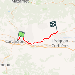
Canal du Midi - Etape 3

frizou83
User

Length
43 km

Max alt
114 m

Uphill gradient
245 m
Km-Effort
47 km

Min alt
46 m

Downhill gradient
297 m
Boucle
No
Creation date :
2016-03-09 00:00:00.0
Updated on :
2016-03-09 00:00:00.0
2h42
Difficulty : Unknown

FREE GPS app for hiking
 SityTrail
IGN / Geographical institutes
SityTrail Plus
The world is yours!
About
Trail Cycle of 43 km to be discovered at Occitania, Aude, Carcassonne. This trail is proposed by frizou83.
Description
Carcassonne
Olonzac

Positioning
Country:
France
Region :
Occitania
Department/Province :
Aude
Municipality :
Carcassonne
Location:
Unknown
Start:(Dec)
Start:(UTM)
447559 ; 4785185 (31T) N.
Comments