


etrechy

olivieraron
User
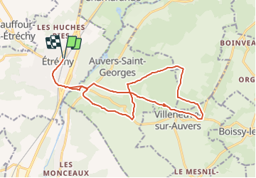

Length
17.6 km

Max alt
150 m

Uphill gradient
233 m
Km-Effort
21 km

Min alt
61 m

Downhill gradient
233 m
Boucle
Yes
Creation date :
2018-08-16 05:48:45.754
Updated on :
2018-08-16 05:48:45.776
6m
Difficulty : Unknown

FREE GPS app for hiking
 SityTrail
IGN / Geographical institutes
SityTrail Plus
The world is yours!
About
Trail Other activity of 17.6 km to be discovered at Ile-de-France, Essonne, Étréchy. This trail is proposed by olivieraron.
Positioning
Country:
France
Region :
Ile-de-France
Department/Province :
Essonne
Municipality :
Étréchy
Location:
Unknown
Start:(Dec)
Start:(UTM)
440464 ; 5371498 (31U) N.
Comments