


Senlis Courteuil données PNR

gilbertdu60
User

Length
8.7 km

Max alt
74 m

Uphill gradient
79 m
Km-Effort
9.8 km

Min alt
43 m

Downhill gradient
73 m
Boucle
No
Creation date :
2016-01-15 00:00:00.0
Updated on :
2016-01-15 00:00:00.0
34m
Difficulty : Medium

FREE GPS app for hiking
 SityTrail
IGN / Geographical institutes
SityTrail Plus
The world is yours!
About
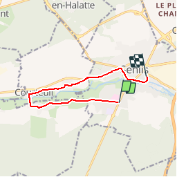
Trail Cycle of 8.7 km to be discovered at Hauts-de-France, Oise, Senlis. This trail is proposed by gilbertdu60.
Description
balade de Senlis à Courteuil retour Senlis
Positioning
Country:
France
Region :
Hauts-de-France
Department/Province :
Oise
Municipality :
Senlis
Location:
Unknown
Start:(Dec)
Start:(UTM)
469185 ; 5449266 (31U) N.
Comments