


Environs du Crès

kephas
User
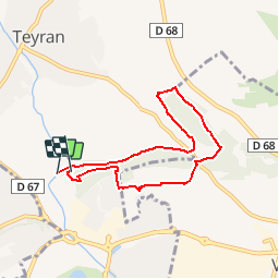

Length
6.9 km

Max alt
85 m

Uphill gradient
75 m
Km-Effort
7.9 km

Min alt
49 m

Downhill gradient
67 m
Boucle
Yes
Creation date :
2016-01-19 00:00:00.0
Updated on :
2016-01-19 00:00:00.0
3h00
Difficulty : Very easy

FREE GPS app for hiking
 SityTrail
IGN / Geographical institutes
SityTrail Plus
The world is yours!
About
Trail Walking of 6.9 km to be discovered at Occitania, Hérault, Le Crès. This trail is proposed by kephas.
Positioning
Country:
France
Region :
Occitania
Department/Province :
Hérault
Municipality :
Le Crès
Location:
Unknown
Start:(Dec)
Start:(UTM)
574797 ; 4835334 (31T) N.
Comments