


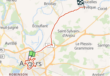
Angers les parcs

bubuserge
User

Length
27 km

Max alt
55 m

Uphill gradient
264 m
Km-Effort
30 km

Min alt
14 m

Downhill gradient
246 m
Boucle
No
Creation date :
2018-12-23 11:34:13.959
Updated on :
2020-05-16 14:32:31.336
3h21
Difficulty : Very easy

FREE GPS app for hiking
 SityTrail
IGN / Geographical institutes
SityTrail Plus
The world is yours!
About
Trail Other activity of 27 km to be discovered at Pays de la Loire, Maine-et-Loire, Angers. This trail is proposed by bubuserge.
Positioning
Country:
France
Region :
Pays de la Loire
Department/Province :
Maine-et-Loire
Municipality :
Angers
Location:
Unknown
Start:(Dec)
Start:(UTM)
684063 ; 5261167 (30T) N.
Comments