


bois de Bonnet en groupe

meillon
User
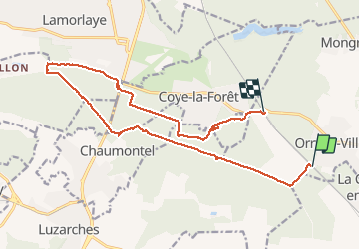

Length
17.3 km

Max alt
134 m

Uphill gradient
239 m
Km-Effort
21 km

Min alt
29 m

Downhill gradient
249 m
Boucle
No
Creation date :
2016-03-09 00:00:00.0
Updated on :
2016-03-09 00:00:00.0
5h01
Difficulty : Easy

FREE GPS app for hiking
 SityTrail
IGN / Geographical institutes
SityTrail Plus
The world is yours!
About
Trail Walking of 17.3 km to be discovered at Hauts-de-France, Oise, Orry-la-Ville. This trail is proposed by meillon.
Description
sympa
Positioning
Country:
France
Region :
Hauts-de-France
Department/Province :
Oise
Municipality :
Orry-la-Ville
Location:
Unknown
Start:(Dec)
Start:(UTM)
463979 ; 5441650 (31U) N.
Comments