


pourville varengeville

olivieraron
User
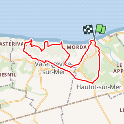

Length
14.3 km

Max alt
110 m

Uphill gradient
303 m
Km-Effort
18.4 km

Min alt
2 m

Downhill gradient
303 m
Boucle
Yes
Creation date :
2019-01-14 09:44:47.837
Updated on :
2019-01-14 09:44:48.001
6m
Difficulty : Unknown

FREE GPS app for hiking
 SityTrail
IGN / Geographical institutes
SityTrail Plus
The world is yours!
About
Trail Other activity of 14.3 km to be discovered at Normandy, Seine-Maritime, Hautot-sur-Mer. This trail is proposed by olivieraron.
Positioning
Country:
France
Region :
Normandy
Department/Province :
Seine-Maritime
Municipality :
Hautot-sur-Mer
Location:
Unknown
Start:(Dec)
Start:(UTM)
358622 ; 5531289 (31U) N.
Comments