


Boug et Comin 4 (par Pont-Arcy)

mick211
User

Length
8.8 km

Max alt
58 m

Uphill gradient
53 m
Km-Effort
9.5 km

Min alt
42 m

Downhill gradient
52 m
Boucle
Yes
Creation date :
2016-03-09 00:00:00.0
Updated on :
2016-03-09 00:00:00.0
2h08
Difficulty : Very easy

FREE GPS app for hiking
 SityTrail
IGN / Geographical institutes
SityTrail Plus
The world is yours!
About
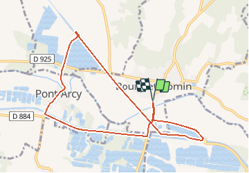
Trail Walking of 8.8 km to be discovered at Hauts-de-France, Aisne, Bourg-et-Comin. This trail is proposed by mick211.
Description
Départ du parking ou se trouve le panneau d'info.......5.5 Km en stoppant la rando (revenir sur la route D 967) après le pont canal ou continuer pour faire 8.8 Km
Photos
 - Photo 1")


Positioning
Country:
France
Region :
Hauts-de-France
Department/Province :
Aisne
Municipality :
Bourg-et-Comin
Location:
Unknown
Start:(Dec)
Start:(UTM)
547450 ; 5471459 (31U) N.
Comments