


thillay

PascalBanide
User
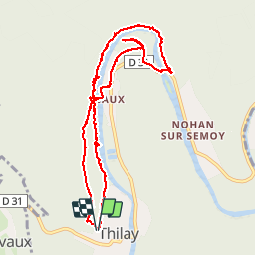

Length
9.4 km

Max alt
226 m

Uphill gradient
188 m
Km-Effort
11.9 km

Min alt
149 m

Downhill gradient
188 m
Boucle
Yes
Creation date :
2016-03-09 00:00:00.0
Updated on :
2016-03-09 00:00:00.0
2h12
Difficulty : Easy

FREE GPS app for hiking
 SityTrail
IGN / Geographical institutes
SityTrail Plus
The world is yours!
About
Trail Other activity of 9.4 km to be discovered at Grand Est, Ardennes, Thilay. This trail is proposed by PascalBanide.
Positioning
Country:
France
Region :
Grand Est
Department/Province :
Ardennes
Municipality :
Thilay
Location:
Unknown
Start:(Dec)
Start:(UTM)
629668 ; 5526181 (31U) N.
Comments