


Compeyre

ARPF
User
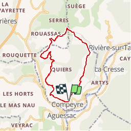

Length
12.7 km

Max alt
628 m

Uphill gradient
348 m
Km-Effort
17.3 km

Min alt
434 m

Downhill gradient
333 m
Boucle
Yes
Creation date :
2016-03-09 00:00:00.0
Updated on :
2016-03-09 00:00:00.0
3h20
Difficulty : Medium

FREE GPS app for hiking
 SityTrail
IGN / Geographical institutes
SityTrail Plus
The world is yours!
About
Trail Walking of 12.7 km to be discovered at Occitania, Aveyron, Compeyre. This trail is proposed by ARPF.
Description
Compeyre
le Puech de Luzergue
Positioning
Country:
France
Region :
Occitania
Department/Province :
Aveyron
Municipality :
Compeyre
Location:
Unknown
Start:(Dec)
Start:(UTM)
508214 ; 4889928 (31T) N.
Comments
les trois châteaux