


combe Sautot

nicolasdresse
User
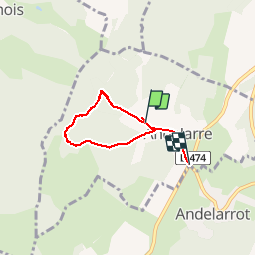

Length
4.8 km

Uphill gradient
210 m
Km-Effort
7.5 km

Downhill gradient
168 m
Boucle
No
Creation date :
2018-09-29 20:52:30.061
Updated on :
2018-09-29 20:52:30.076
1h21
Difficulty : Unknown

FREE GPS app for hiking
 SityTrail
IGN / Geographical institutes
SityTrail Plus
The world is yours!
About
Trail Other activity of 4.8 km to be discovered at Bourgogne-Franche-Comté, Haute-Saône, Andelarre. This trail is proposed by nicolasdresse.
Photos

Positioning
Country:
France
Region :
Bourgogne-Franche-Comté
Department/Province :
Haute-Saône
Municipality :
Andelarre
Location:
Unknown
Start:(Dec)
Start:(UTM)
281302 ; 5274956 (32T) N.
Comments