Trail Mountain bike Varces-Allières-et-Risset - cascade- tour st paul - 2 rocheforts - claix - Photo

cascade- tour st paul - 2 rocheforts - claix

© OpenStreetMap contributors
Length
Length
24 km
Max alt
Max alt
438 m
Uphill gradient
Uphill gradient
608 m
Km-Effort
Km-Effort  
32 km
Min alt
Min alt
240 m
Downhill gradient
Downhill gradient
607 m
Boucle
Boucle
Yes
Creation date :
2016-03-09 00:00:00.0
Updated on :
2016-03-09 00:00:00.0

(0 Reviews)

Mountain bike
Mountain bike
1h36
Difficulty : Medium

Scan this QR Code to open this trail in the SityTrail application

FREE GPS app for hiking

Logo SityTrail SityTrail

IGN / Geographical institutes

Download SityTrail from the App Store Download SityTrail from Google Play

Logo SityTrail SityTrail World

The world is yours!

Download SityTrail from the App Store Download SityTrail from Google Play Download SityTrail on Huawei AppGallery

About

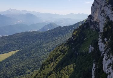
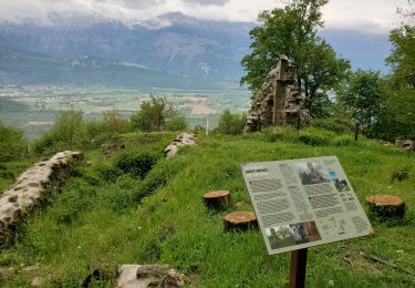
Trail Mountain bike of 24 km to be discovered at Auvergne-Rhône-Alpes, Isère, Varces-Allières-et-Risset. This trail is proposed by leviking73.

Description

boucle type cross country. nombreux singles. à faire dans les deux sens. léger poussage dans grand Rochefort.

Elevation profile

Positioning

Country:
France
Region :
Auvergne-Rhône-Alpes
Department/Province :
Isère
Municipality :
Varces-Allières-et-Risset
Location:
Unknown
Start:(UTM)
710081 ; 4997964 (31T) N.

Trails nearby

Trail Snowshoes Lans-en-Vercors - La Crête des Ramées de nuit en raquettes - Photo
Snowshoes
patjobou

Snowshoes

Medium
(1)
Lans-en-Vercors, Auvergne-Rhône-Alpes, Isère, France
8 km | 13.4 km-effort
4h 9min
Yes
Trail Walking Lans-en-Vercors - Le Pic saint michel - Photo
Walking
patjobou

Walking

Easy
(1)
Lans-en-Vercors, Auvergne-Rhône-Alpes, Isère, France
6.5 km | 13.2 km-effort
2h 38min
No
Trail Walking Lans-en-Vercors - le vertige des cimes - Photo
Walking
jeanfcd

Walking

Medium
(1)
Lans-en-Vercors, Auvergne-Rhône-Alpes, Isère, France
6.3 km | 11 km-effort
2h 9min
Yes
Trail Walking Claix - caba - Photo
Walking
Sylvie Mathiot

Walking

Very easy
(1)
Claix, Auvergne-Rhône-Alpes, Isère, France
8.7 km | 16.6 km-effort
5h 2min
Yes
Trail Nordic walking Claix - Le Peuil 5 Km - Photo
Nordic walking
patjobou

Nordic walking

Easy
(1)
Claix, Auvergne-Rhône-Alpes, Isère, France
5.3 km | 7.1 km-effort
1h 28min
Yes
Trail Walking Lans-en-Vercors - Belvédère de Lans (Passerelle) Eté - Photo
Walking
patjobou

Walking

Easy
(1)
Lans-en-Vercors, Auvergne-Rhône-Alpes, Isère, France
5.8 km | 10.3 km-effort
1h 20min
Yes
Trail Walking Champ-sur-Drac - 38 Couvent St Michel Champ / drac - Photo
Walking
ericf64

Walking

Medium
Champ-sur-Drac, Auvergne-Rhône-Alpes, Isère, France
9.4 km | 19.7 km-effort
3h 0min
Yes
Trail Walking Seyssins - moucheroutte  - Photo
Walking
Youcef Atallah

Walking

Very difficult
Seyssins, Auvergne-Rhône-Alpes, Isère, France
25 km | 43 km-effort
5h 0min
No
Trail Walking Varces-Allières-et-Risset - Les Etangs de Reymure réaménagés en 2023. - Photo
Walking
patjobou

Walking

Medium
Varces-Allières-et-Risset, Auvergne-Rhône-Alpes, Isère, France
7.9 km | 8.6 km-effort
2h 35min
Yes


Close
My subscriptions