


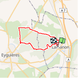
Les grottes de Calés

perini
User

Length
12.2 km

Max alt
306 m

Uphill gradient
345 m
Km-Effort
16.9 km

Min alt
100 m

Downhill gradient
351 m
Boucle
Yes
Creation date :
2016-03-09 00:00:00.0
Updated on :
2016-03-09 00:00:00.0
3h31
Difficulty : Medium

FREE GPS app for hiking
 SityTrail
IGN / Geographical institutes
SityTrail Plus
The world is yours!
About
Trail Walking of 12.2 km to be discovered at Provence-Alpes-Côte d'Azur, Bouches-du-Rhône, Lamanon. This trail is proposed by perini.
Positioning
Country:
France
Region :
Provence-Alpes-Côte d'Azur
Department/Province :
Bouches-du-Rhône
Municipality :
Lamanon
Location:
Unknown
Start:(Dec)
Start:(UTM)
667896 ; 4840838 (31T) N.
Comments