


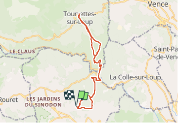
Roquefort les pins Tourette sur loup

GrouGary
User

Length
18.2 km

Max alt
422 m

Uphill gradient
705 m
Km-Effort
28 km

Min alt
41 m

Downhill gradient
705 m
Boucle
Yes
Creation date :
2016-03-09 00:00:00.0
Updated on :
2024-04-09 18:25:53.963
6h16
Difficulty : Medium

FREE GPS app for hiking
 SityTrail
IGN / Geographical institutes
SityTrail Plus
The world is yours!
About
Trail Walking of 18.2 km to be discovered at Provence-Alpes-Côte d'Azur, Maritime Alps, Roquefort-les-Pins. This trail is proposed by GrouGary.
Description
A/R sauf qq boucles
Positioning
Country:
France
Region :
Provence-Alpes-Côte d'Azur
Department/Province :
Maritime Alps
Municipality :
Roquefort-les-Pins
Location:
Unknown
Start:(Dec)
Start:(UTM)
343336 ; 4837159 (32T) N.
Comments