


09 - 28 février 2016 GRBA

ace003
User

Length
23 km

Max alt
152 m

Uphill gradient
178 m
Km-Effort
25 km

Min alt
106 m

Downhill gradient
178 m
Boucle
Yes
Creation date :
2016-03-09 00:00:00.0
Updated on :
2016-03-09 00:00:00.0
6h40
Difficulty : Easy

FREE GPS app for hiking
 SityTrail
IGN / Geographical institutes
SityTrail Plus
The world is yours!
About
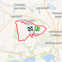
Trail Walking of 23 km to be discovered at Grand Est, Aube, Épagne. This trail is proposed by ace003.
Positioning
Country:
France
Region :
Grand Est
Department/Province :
Aube
Municipality :
Épagne
Location:
Unknown
Start:(Dec)
Start:(UTM)
608388 ; 5361015 (31U) N.
Comments