


compostelle gr65 de condom a montreal

phimar_2612
User
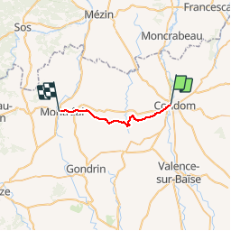

Length
17.7 km

Max alt
180 m

Uphill gradient
302 m
Km-Effort
22 km

Min alt
72 m

Downhill gradient
253 m
Boucle
No
Creation date :
2016-03-09 00:00:00.0
Updated on :
2016-03-09 00:00:00.0
--
Difficulty : Medium

FREE GPS app for hiking
 SityTrail
IGN / Geographical institutes
SityTrail Plus
The world is yours!
About
Trail Walking of 17.7 km to be discovered at Occitania, Gers, Condom. This trail is proposed by phimar_2612.
Positioning
Country:
France
Region :
Occitania
Department/Province :
Gers
Municipality :
Condom
Location:
Unknown
Start:(Dec)
Start:(UTM)
288856 ; 4870500 (31T) N.
Comments