


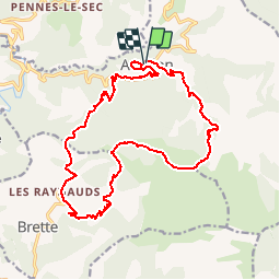
Aucelon serre de l'Eglise

bymarc26
User

Length
19.7 km

Max alt
1295 m

Uphill gradient
837 m
Km-Effort
31 km

Min alt
608 m

Downhill gradient
839 m
Boucle
Yes
Creation date :
2016-03-09 00:00:00.0
Updated on :
2016-03-09 00:00:00.0
6h00
Difficulty : Difficult

FREE GPS app for hiking
 SityTrail
IGN / Geographical institutes
SityTrail Plus
The world is yours!
About
Trail Walking of 19.7 km to be discovered at Auvergne-Rhône-Alpes, Drôme, Aucelon. This trail is proposed by bymarc26.
Positioning
Country:
France
Region :
Auvergne-Rhône-Alpes
Department/Province :
Drôme
Municipality :
Aucelon
Location:
Unknown
Start:(Dec)
Start:(UTM)
686054 ; 4943961 (31T) N.
Comments