


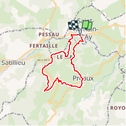
St Romain d'Ay

jpduc
User

Length
12.7 km

Max alt
647 m

Uphill gradient
375 m
Km-Effort
17.7 km

Min alt
415 m

Downhill gradient
376 m
Boucle
Yes
Creation date :
2016-03-12 00:00:00.0
Updated on :
2016-03-12 00:00:00.0
3h45
Difficulty : Easy

FREE GPS app for hiking
 SityTrail
IGN / Geographical institutes
SityTrail Plus
The world is yours!
About
Trail Walking of 12.7 km to be discovered at Auvergne-Rhône-Alpes, Ardèche, Saint-Romain-d'Ay. This trail is proposed by jpduc.
Description
Balade en Nord-Ardèche dans les environs d'Annonay
Positioning
Country:
France
Region :
Auvergne-Rhône-Alpes
Department/Province :
Ardèche
Municipality :
Saint-Romain-d'Ay
Location:
Unknown
Start:(Dec)
Start:(UTM)
630636 ; 5002476 (31T) N.
Comments