


Vagevuurbossen

2heavy
User
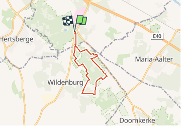

Length
9.4 km

Max alt
37 m

Uphill gradient
111 m
Km-Effort
10.9 km

Min alt
11 m

Downhill gradient
111 m
Boucle
Yes
Creation date :
2016-05-10 00:00:00.0
Updated on :
2016-05-10 00:00:00.0
2h10
Difficulty : Easy

FREE GPS app for hiking
 SityTrail
IGN / Geographical institutes
SityTrail Plus
The world is yours!
About
Trail Walking of 9.4 km to be discovered at Flanders, West Flanders, Beernem. This trail is proposed by 2heavy.
Description
Prachtige zeer rustige wandeling.
Waterdicht schoeisel bij regenperiodes aangeraden.
Points of interest


Positioning
Country:
Belgium
Region :
Flanders
Department/Province :
West Flanders
Municipality :
Beernem
Location:
Beernem
Start:(Dec)
Start:(UTM)
521970 ; 5661914 (31U) N.
Comments