


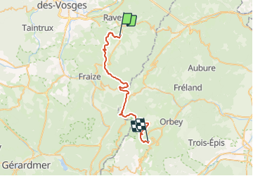
Circuit Alsace Vosges Ban De Laveline Orbey par Bonhomme

Tourisme Equestre Alsace
Promouvoir le Tourisme Equestre en Alsace GUIDE+

Length
34 km

Max alt
1149 m

Uphill gradient
1371 m
Km-Effort
51 km

Min alt
422 m

Downhill gradient
932 m
Boucle
No
Creation date :
2016-03-15 00:00:00.0
Updated on :
2022-02-02 15:24:06.472
6h00
Difficulty : Very difficult

FREE GPS app for hiking
 SityTrail
IGN / Geographical institutes
SityTrail Plus
The world is yours!
About
Trail Horseback riding of 34 km to be discovered at Grand Est, Vosges, Ban-de-Laveline. This trail is proposed by Tourisme Equestre Alsace.
Photos


Positioning
Country:
France
Region :
Grand Est
Department/Province :
Vosges
Municipality :
Ban-de-Laveline
Location:
Unknown
Start:(Dec)
Start:(UTM)
356126 ; 5344792 (32U) N.
Comments