


brugelette2

mozzipsc
User
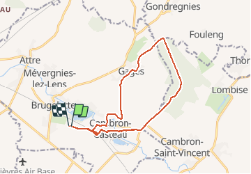

Length
13.3 km

Max alt
94 m

Uphill gradient
129 m
Km-Effort
15 km

Min alt
46 m

Downhill gradient
132 m
Boucle
Yes
Creation date :
2016-03-17 00:00:00.0
Updated on :
2016-03-17 00:00:00.0
2h39
Difficulty : Very easy

FREE GPS app for hiking
 SityTrail
IGN / Geographical institutes
SityTrail Plus
The world is yours!
About
Trail Walking of 13.3 km to be discovered at Wallonia, Hainaut, Brugelette. This trail is proposed by mozzipsc.
Description
Autour de Pairi Daiza traversant le bois de la Provision
Positioning
Country:
Belgium
Region :
Wallonia
Department/Province :
Hainaut
Municipality :
Brugelette
Location:
Brugelette (section)
Start:(Dec)
Start:(UTM)
561011 ; 5604519 (31U) N.
Comments