


balisage 19 mars 2016 MACEY

ace003
User

Length
6.8 km

Max alt
271 m

Uphill gradient
96 m
Km-Effort
8.2 km

Min alt
181 m

Downhill gradient
124 m
Boucle
No
Creation date :
2016-03-20 00:00:00.0
Updated on :
2016-03-20 00:00:00.0
2h55
Difficulty : Easy

FREE GPS app for hiking
 SityTrail
IGN / Geographical institutes
SityTrail Plus
The world is yours!
About
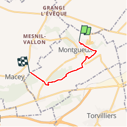
Trail Walking of 6.8 km to be discovered at Grand Est, Aube, Montgueux. This trail is proposed by ace003.
Photos


31 photos in total. Please click on a photo to see them all in the gallery.
Positioning
Country:
France
Region :
Grand Est
Department/Province :
Aube
Municipality :
Montgueux
Location:
Unknown
Start:(Dec)
Start:(UTM)
571205 ; 5351096 (31U) N.
Comments