


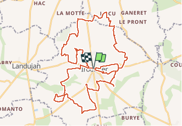
23.03.2016 - IRODOUER

babeth35
User

Length
30 km

Max alt
147 m

Uphill gradient
224 m
Km-Effort
33 km

Min alt
85 m

Downhill gradient
220 m
Boucle
Yes
Creation date :
2016-03-23 00:00:00.0
Updated on :
2020-07-20 15:36:47.961
8h26
Difficulty : Easy

FREE GPS app for hiking
 SityTrail
IGN / Geographical institutes
SityTrail Plus
The world is yours!
About
Trail Walking of 30 km to be discovered at Brittany, Ille-et-Vilaine, Irodouër. This trail is proposed by babeth35.
Positioning
Country:
France
Region :
Brittany
Department/Province :
Ille-et-Vilaine
Municipality :
Irodouër
Location:
Unknown
Start:(Dec)
Start:(UTM)
577969 ; 5344579 (30U) N.
Comments