


Viglain (Loiret)

Ordijamo45
User
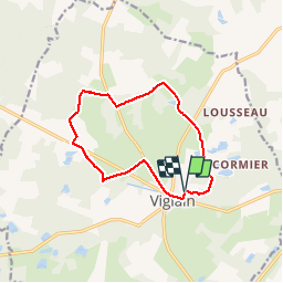

Length
11.2 km

Max alt
155 m

Uphill gradient
76 m
Km-Effort
12.2 km

Min alt
126 m

Downhill gradient
75 m
Boucle
Yes
Creation date :
2019-05-03 09:15:15.179
Updated on :
2019-05-03 09:15:15.25
2h42
Difficulty : Easy

FREE GPS app for hiking
 SityTrail
IGN / Geographical institutes
SityTrail Plus
The world is yours!
About
Trail Walking of 11.2 km to be discovered at Centre-Loire Valley, Loiret, Viglain. This trail is proposed by Ordijamo45.
Description
Promenade en forêt d'Orléans
Positioning
Country:
France
Region :
Centre-Loire Valley
Department/Province :
Loiret
Municipality :
Viglain
Location:
Unknown
Start:(Dec)
Start:(UTM)
447985 ; 5286451 (31T) N.
Comments