


kirbpnouveau guide

ARPF
User

Length
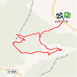
9.8 km

Max alt
636 m

Uphill gradient
265 m
Km-Effort
13.3 km

Min alt
404 m

Downhill gradient
264 m
Boucle
Yes
Creation date :
2016-03-25 00:00:00.0
Updated on :
2016-03-25 00:00:00.0
2h51
Difficulty : Unknown

FREE GPS app for hiking
 SityTrail
IGN / Geographical institutes
SityTrail Plus
The world is yours!
About
Trail Walking of 9.8 km to be discovered at Provence-Alpes-Côte d'Azur, Bouches-du-Rhône, Trets. This trail is proposed by ARPF.
Positioning
Country:
France
Region :
Provence-Alpes-Côte d'Azur
Department/Province :
Bouches-du-Rhône
Municipality :
Trets
Location:
Unknown
Start:(Dec)
Start:(UTM)
715986 ; 4810193 (31T) N.
Comments