


Mas Rochebelle

alcadissahar
User
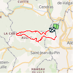

Length
12.3 km

Max alt
559 m

Uphill gradient
459 m
Km-Effort
18.7 km

Min alt
147 m

Downhill gradient
531 m
Boucle
No
Creation date :
2016-03-27 00:00:00.0
Updated on :
2016-03-27 00:00:00.0
2h44
Difficulty : Medium

FREE GPS app for hiking
 SityTrail
IGN / Geographical institutes
SityTrail Plus
The world is yours!
About
Trail Walking of 12.3 km to be discovered at Occitania, Gard, Alès. This trail is proposed by alcadissahar.
Photos


Positioning
Country:
France
Region :
Occitania
Department/Province :
Gard
Municipality :
Alès
Location:
Unknown
Start:(Dec)
Start:(UTM)
584979 ; 4887294 (31T) N.
Comments