


St-André de Roquepertuis, Sabonadière

ggtasie
User
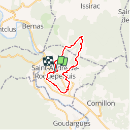

Length
10 km

Max alt
285 m

Uphill gradient
325 m
Km-Effort
14.4 km

Min alt
92 m

Downhill gradient
331 m
Boucle
Yes
Creation date :
2016-03-29 00:00:00.0
Updated on :
2016-03-29 00:00:00.0
3h06
Difficulty : Medium

FREE GPS app for hiking
 SityTrail
IGN / Geographical institutes
SityTrail Plus
The world is yours!
About
Trail Walking of 10 km to be discovered at Occitania, Gard, Saint-André-de-Roquepertuis. This trail is proposed by ggtasie.
Positioning
Country:
France
Region :
Occitania
Department/Province :
Gard
Municipality :
Saint-André-de-Roquepertuis
Location:
Unknown
Start:(Dec)
Start:(UTM)
616353 ; 4899587 (31T) N.
Comments