


30.03.2016 - St Thurial

babeth35
User
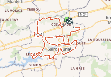

Length
27 km

Max alt
107 m

Uphill gradient
343 m
Km-Effort
32 km

Min alt
41 m

Downhill gradient
350 m
Boucle
No
Creation date :
2018-04-11 23:08:44.838
Updated on :
2020-07-20 15:36:04.149
6h57
Difficulty : Easy

FREE GPS app for hiking
 SityTrail
IGN / Geographical institutes
SityTrail Plus
The world is yours!
About
Trail Walking of 27 km to be discovered at Brittany, Ille-et-Vilaine, Saint-Thurial. This trail is proposed by babeth35.
Positioning
Country:
France
Region :
Brittany
Department/Province :
Ille-et-Vilaine
Municipality :
Saint-Thurial
Location:
Unknown
Start:(Dec)
Start:(UTM)
579978 ; 5321979 (30U) N.
Comments