


parcours vers lachamp

Quentin48
User
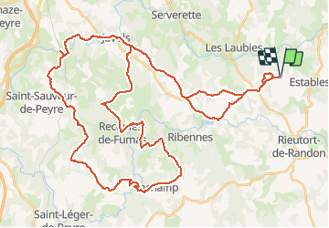

Length
65 km

Max alt
1180 m

Uphill gradient
1300 m
Km-Effort
82 km

Min alt
862 m

Downhill gradient
1299 m
Boucle
Yes
Creation date :
2016-03-30 00:00:00.0
Updated on :
2016-03-30 00:00:00.0
4h30
Difficulty : Difficult

FREE GPS app for hiking
 SityTrail
IGN / Geographical institutes
SityTrail Plus
The world is yours!
About
Trail Mountain bike of 65 km to be discovered at Occitania, Lozère, Monts-de-Randon. This trail is proposed by Quentin48.
Description
Passage difficile après le moulin de Lachamp
Positioning
Country:
France
Region :
Occitania
Department/Province :
Lozère
Municipality :
Monts-de-Randon
Location:
Saint-Amans
Start:(Dec)
Start:(UTM)
536877 ; 4946480 (31T) N.
Comments